


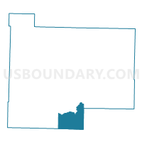
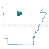
Shady Grove Voting District, Searcy County, Arkansas
About
Outline

Summary
| Unique Area Identifier | 528113 |
| Name | Shady Grove Voting District |
| County | Searcy County |
| State | Arkansas |
| Area (square miles) | 25.48 |
| Land Area (square miles) | 25.46 |
| Water Area (square miles) | 0.02 |
| % of Land Area | 99.92 |
| % of Water Area | 0.08 |
| Latitude of the Internal Point | 35.74366350 |
| Longtitude of the Internal Point | -92.65514080 |
Maps

Graphs
Select a template below for downloading or customizing gragh for Shady Grove Voting District, Searcy County, Arkansas


Neighbors
Neighoring Voting District (by Name) Neighboring Voting District on the Map
- Mt. Pleasant Voting District, Searcy County, AR
- Red River Voting District, Searcy County, AR
- Washington Voting District, Van Buren County, AR
Top 10 Neighboring County Subdivision (by Population) Neighboring County Subdivision on the Map
- Washington township, Van Buren County, AR (850)
- Mount Pleasant township, Searcy County, AR (465)
- Red River township, Searcy County, AR (321)
- Shady Grove township, Searcy County, AR (189)
- Archey Valley township, Van Buren County, AR (144)